|
Meeting Locations
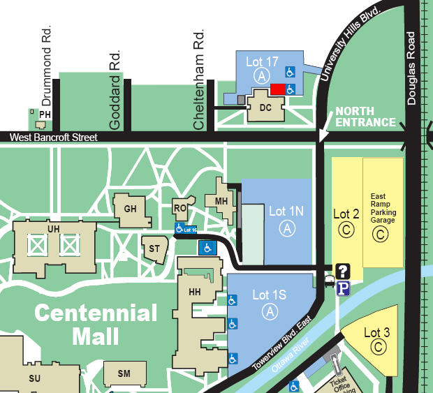
TAA Meetings Location McMaster Hall (map below)
From the south or the Ohio Turnpike (Use exit 64):
- Follow I-75 north to I-475 (Exit 204).
- Travel west on I-475 to the fourth exit, Secor Road (Exit 17).
- Turn left onto Secor Road, proceed 2 mi . (South)
- Turn left onto Bancroft Street, proceed 1/2 mi. (East)
- Turn right onto Towerview Boulevard East.
- Turn right at first stop sign for parking.
From the north (Detroit):
- Follow I-75 south to I-475.
- Travel west on I-475 to the fourth exit, Secor Road (Exit 17).
- Turn left onto Secor Road, proceed 2 mi . (South)
- Turn left onto Bancroft Street, proceed 1/2 mi. (East)
- Turn right onto Towerview Boulevard East.
- Turn right at first stop sign for parking.
From the west:
- Follow I-475 north to I-475 east .
- Travel east on I-475 to the Secor Rd. exit (Exit 17).
- Turn right onto Secor Road, proceed 2 mi . (South)
- Turn left onto Bancroft Street, proceed 1/2 mi. (East)
- Turn right onto Towerview Boulevard East.
- Turn right at first stop sign for parking.
Latitude
N41 39.696
Longitude
W83 36.690
McMaster Hall (MH) and Ritter Observatory (RO) are both located on the west side of Lot 1N.
Do not pay for parking if an event is also underway, inform parking staff that you are here for a meeting.
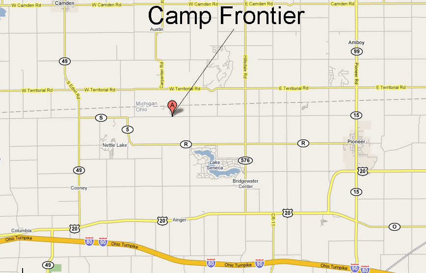
Directions to Pioneer Scout Reservation (PSR):
Take US-20 West to US-127, bear left (South) and then right, back West on US-20. Pass the traffic light leading into Pioneer in favor of going straight West and maintain straight when the highway bends. By doing that you wind up on back road County Q. If you miss that road just continue to SR-576 and then go right (North). Others prefer to go through Pioneer. In any event just work your way over to Roads "S" & "8". This is about 5 miles West of the town. Watch out for critters crossing the road!
PSR is West of the intersection of County Roads "S" and "8" on Co. Rd. S. Lettered roads run East-West and numbered roads run North-South. Once at S & 8 go West on the rough gravel road about a 1/4 mile to the entrance on the North side of the road. Go past the home and the "physical plant" type operations to a set of structures, the one on the left being a mess hall, and look for the people or signs.
Latitude: 41.40096
Longitude: -84.14147
Map to PSR
Observing Locations
Lake Hudson Dark Sky Preserve - Hudson MI, Michigan State Park admission required.
For more information about the park or to get night time use permission contact the Park Manager at:
W. J. HAYES STATE PARK
1220 WAMPLER’S LAKE ROAD
ONSTED MI 49265
Phone # (517) 467-7401
Latitude: 41.82787
Longitude: -84.23578
Take US 23 north to Exit 5. Take 223 West to Adrian. Take 52 north about a mile. Take 34 West from Adrian Mi.
Take 156 South to the park entrance.
Map to Hudson Lake SP.
|


